Hazardous Weather Outlook
National Weather Service State College PA
204 PM EDT Fri Jun 6 2025
PAZ004>006-010>012-017>019-024>028-033>035-037-041-042-045-046- 049>053-071815- Warren-McKean-Potter-Elk-Cameron-Northern Clinton-Clearfield-Northern Centre-Southern Centre-Cambria-Blair Huntingdon-Mifflin-Juniata-Somerset-Bedford-Fulton-Tioga-Northern Lycoming-Sullivan-Southern Clinton-Southern Lycoming-Union-Snyder-Montour-Northumberland-Columbia- 204 PM EDT Fri Jun 6 2025
This Hazardous Weather Outlook is for central Pennsylvania.
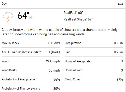
.DAY ONE...This afternoon and tonight.
Strong to severe thunderstorms with gusty winds are possible mainly from the mid afternoon through the early evening hours. Brief heavy rain could lead to minor flooding problems.
.DAYS TWO THROUGH SEVEN...Saturday through Thursday.
Strong to severe thunderstorms with gusty winds are possible, and brief heavy rain may also lead to minor flooding problems on Sunday.
.SPOTTER INFORMATION STATEMENT...
Spotters are encouraged to report significant hazardous weather.